
How to research historic houses: aerial photographs
- Mark Belloni
- May 24
- 7 min read

Updated: May 27
Aerial photographs are often overlooked in historic home research in favor of more commonly consulted sources such as deeds, maps, and newspapers. However, they are extremely valuable and can reveal a wide range of information about a historic property and its surrounding landscape. Aerials are especially useful for rural properties, where visual documentation is often far more limited than it is for properties located within towns or city limits.
Aerials exist in two primary formats: high-altitude aerials and commercial farm aerials. In this blog, I'll explain each and how they can be leveraged to research historic properties.
High-altitude aerials
High-altitude aerial photographs first emerged out of military necessity in the early 20th century, when aviation made it possible to see entire landscapes from above in a systematic way for the first time. During World War I, cameras mounted in aircraft were used to document enemy positions, trench systems, and transportation routes, quickly proving how valuable it was to view the landscape at scale rather than in fragments from the ground. By the time of World War II, aerial photography had become fully embedded in military intelligence and mapping operations, refined into a routine tool for interpreting terrain and tracking change over time.
After the war, those same techniques were carried into civilian life and adapted for large-scale mapping and land management. Federal agencies such as the United States Geological Survey and the U.S. Department of Agriculture began producing systematic aerial coverage of entire regions for documentation and measurement purposes. These images were typically taken from high altitude in a straight vertical orientation, creating a consistent, almost grid-like record of the landscape. Today, due to their government use, many can be found in county and state archives across the country.
How high-altitude aerials can help with historic house research
A now-demolished home in rural Indiana provides a classic example of how high-altitude aerials can be used in historical research.
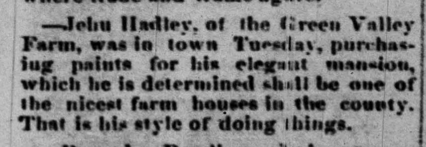
Starting in 1876 and finishing in 1877, Jehu Hadley and Jerusha Stiles Hadley constructed a handsome brick Italianate farmhouse in Franklin Township, Hendricks County. The home served as the centerpiece of Green Valley Farm, their sprawling, 400-acre property. Its construction was covered often in local papers:


The house was completed at the same time that the 1878 Atlas of Hendricks County. was being compiled, and the Hadleys paid to have a lithograph of the house and farm included in the atlas. Alongside the view of the property was a depiction of the Old Settlers’ Reunion, which was held on the grounds of Green Valley Farm for over a decade.

Sadly, no trace of Green Valley Farm exists today. As you drive down the county road where the farm once stood, all you see are cornfields. If you did not know what once stood there, you would never suspect that a prominent brick farmhouse, extensive farm buildings, and even large public gatherings once occupied the site.
When did Green Valley Farm disappear from the landscape? High-altitude aerials can help narrow down a date. Starting with a 1946 aerial, the farm and the Hadley residence are still clearly visible:

Comparing the 1946 high-altitude aerial to the 1878 lithograph reveals that the overall layout of the farm remained largely intact over a span of nearly 70 years. The Hadley residence still sits at the center of a tree-filled yard, with a curved drive extending westward past a collection of farm buildings.
Additionally, a fenced strip of land extends north from the farmstead and connects to a wooded area along the banks of Mill Creek. This may have been the portion of the property that hosted the Old Settlers’ Reunion for several consecutive years.
By 1958, we see distinct changes to the property:

The 1958 image, likely taken in the summer, is heavily obscured by tree canopy, which blocks much of the detail that is visible in the 1946 aerial. Even so, it is reasonable to conclude that the 1876 Hadley house is still standing beneath the trees, as its yard remains clearly defined and maintained as a distinct space separate from the surrounding fields. The gravel drive extending westward is also still clearly visible, suggesting the property is still inhabited.
On the other hand, the wooded area to the north of the farmstead appears to have been abandoned. This suggests that Green Valley Farm was beginning to scale down, or at least shifting away from its earlier level of maintenance and use. Taken together, these changes may indicate a broader transition in the farm’s operation, if not an outright decline in its active agricultural function.
Twelve years later, in 1970, the transformation was even more stark:

Here we can see that the entire Green Valley Farm property has been reduced to just a small collection of trees and brush near the road. Gone are the clean fence lines, outbuildings, gravel drive, and the Hadley residence.
Looking at this series of aerials from 1946 to 1970, it is clear that the brick Italianate farmhouse built by the Hadleys in 1876 survived until at least 1958, but was demolished sometime between 1958 and 1970. Taken together, the high-altitude aerials from 1946, 1958, and 1970 demonstrate how these images can be used to track the life cycle of a historic property when on-the-ground documentation is limited or absent. In the case of the Hadley residence, they provide a rare, continuous visual record that allows us to narrow its disappearance to a specific twelve-year window.
Commercial farm aerials
Commercial farm aerials developed a little later and in a very different context than high-altitude aerials. Rather than emerging from military or mapping programs, they grew out of post–World War II rural entrepreneurship and the expanding availability of small aircraft and portable camera equipment. By the mid-20th century, individual photographers and small companies were flying low-altitude routes over rural areas, photographing nearly every farmstead they passed. Instead of precision mapping, the goal was to create a more personal and visually appealing image of a specific property.
What made these photographs distinctive was their intent and perspective. Unlike vertical survey aerials, farm aerials were usually shot at an angle that allowed the farmhouse, barns, fields, and surrounding landscape to be captured in the same frame. They were then sold directly back to property owners, often through traveling salesmen who visited rural homes with sample prints. Many of these photographs have been digitized and today are available online at Vintageaerial.com.
How commercial farm aerials can help with historic house research
The value of commercial farm aerials lies in the fact that they effectively function as unofficial historic structure inventories completed before formal preservation surveys began in many states, particularly throughout the Midwest. While these photographs were created as commercial products rather than preservation documents, they nevertheless recorded thousands of historic houses, barns, and farmsteads.
Indiana serves as a good example. Official county-wide inventories of historic structures did not begin in the state until 1978, with only a handful of counties surveyed each year thereafter. By that point, however, the commercial farm aerial industry had already been active for decades. As a result, an enormous number of Indiana’s historic rural properties had already been photographed by private aerial photographers long before official surveys ever reached them.
To understand the value of this even further, let’s look at Hendricks County specifically. The county’s first comprehensive historic structures inventory was not completed until 1989. By that point, however, many of the county’s historic rural properties had already been lost and therefore were never documented. Commercial aerials can be used to help identify some of these properties. Two such examples are below:


Both of these houses would have been included in the 1989 county survey. Both are conspicuously missing, indicating they were likely demolished by the time of the survey. If it weren’t for the farm aerials, there would be no easily identifiable visual record of either, and they would have quickly been lost to history.
Farm aerials are also valuable tools for identifying historic houses shown in photographs with no location noted. The photograph below, in the collections of the Plainfield-Guilford Township Public Library, only notes on the back that it is the “house built by John J. Jackson.”

At first glance, the photograph appears to offer a clear starting point for identification. In practice, however, that kind of label is often not enough on its own to confidently locate a specific property.
In this case, multiple John Jacksons appear in historic atlases of Hendricks County, spread across different townships and land parcels, with no surviving house at several of the associated locations that matches the structure in the photograph. Additionally, no structure in the 1989 county-wide survey matches the house either.
However, by browsing available farm aerials for the parcels of land identified as having been owned by John J. Jackson, the house can be located in its original setting. Key features, including its two-story bay projection, classical porch, and decorative eaves, make identification rather straightforward:

Since the home appears to have been demolished before the county-wide 1989 survey, commercial farm aerials remain one of the only ways that the photograph in the collections of the Plainfield-Guilford Township Public Library could have been positively identified and tied to a specific location.
Recap
Historic aerial photographs—both high-altitude government surveys and commercial farm aerials—are an underutilized but highly effective tool for researching historic houses. When traditional documentation is limited or absent, these images provide a visual record that can reveal changes to individual farmsteads, track demolition dates, and help locate structures that no longer exist. Taken together, they bridge critical gaps in the historical record and preserve evidence of rural built environments that would otherwise be lost.


