
The history of Garfield Park's southside neighborhood
- Mark Belloni
- Apr 7
- 20 min read

After publishing a blog post based on a property history report I completed for a client living on the north edge of Garfield Park, a resident on the south side reached out, wanting to know more about their home. I was excited to dive into the history of their neighborhood—it offered another opportunity to explore a seemingly ordinary place.
These are the places I’m drawn to most. Their stories are often scattered or forgotten, and I find a deep sense of purpose in bringing them back to light.
-Mark
Getting oriented
The stories in this post unfold on the land just south of Garfield Park, bounded by Southern Avenue, Shelby Street, Troy Avenue, and the CSX railroad.

The land between East Street and the railroad shares a similar early history, but it followed a slightly different path as it was developed. That story will have to wait for another day.
Additionally, it’s important to note that this land’s history reaches back long before American settlers arrived in Indiana. This story, however, begins in 1842, when Richardson and Isabel Yoke made it their home.
The Yoke family
For most of the 19th century, the land south of Garfield Park was home to the 160-acre farm of Richardson (often called Allen, his middle name) and Isabel Moore Yoke. A 1931 Indianapolis Star article gives a fascinating glimpse into the farm's early years.
The land was originally the Moore family farm, where Isabel grew up. In 1842, Allen purchased it from Isabel’s brother, built a simple frame house, and began his own farming operation. There, the couple raised nine children—John, Sarah, Catherine, Nelson, Mary, Richardson, George, Ella, and Charles.
During the mid-nineteenth century, the Yokes’ land was largely a dense hardwood forest, punctuated by small clearings they created to raise crops and livestock. They lived in a world of their own; their neighbors in the city were separated from them by several miles of forest and farmland.
The farm stood along the road connecting Indianapolis to Shelbyville, with Bean Creek meandering through its northeast corner, carrying water to Pleasant Run and, eventually, the White River.
Early in the 1840s, Allen and Isabel sold a right-of-way across their land to the Madison & Indianapolis Railroad, the first rail line to reach the city. When it was completed in 1847, the family had a front-row view from their farm as the first train rolled into Indianapolis.

As the decades passed, the Yoke family continued much as they always had, their lives shaped by the quiet rhythms of farm work, interrupted only by the occasional rumble of the nearby railroad. In addition to farming, they operated a small dairy.
But Indianapolis was creeping steadily southward, its streets and industry inching closer to their fields. Allen would not live to see the day when his land, once isolated and wooded, met the city at its edge. In 1876—the same year the city established Garfield Park just across the way—Allen died, leaving his family to witness a world in transition without him. The Indianapolis News carried a brief notice of his death:

Isabel remained on the family’s 160 acres, with sons Richardson and George staying with her to help run the dairy. In 1893, Isabel died at the age of eighty, and the long era of the Yoke farm began to come to an end.

After Isabel’s death, the Yoke farm passed into joint ownership among her children and, in cases where a child had already died, their surviving children. By 1893, the reality was clear to Isabel's family: their 160-acre farm, now situated on the southern edge of Indianapolis, had become prime land for sale and development. The time had come for the land that had sustained the family for decades to be divided, sold, and reshaped into something entirely new.
The Yoke Heirs Subdivision
In 1895, the Yoke heirs petitioned the Marion County Superior Court to partition their parents’ land, dividing it into sixteen ten-acre parcels laid out along a grid of public streets bearing names associated with the family. The resulting Yoke Heirs Subdivision was officially platted on December 28, 1895, and recorded with the Marion County Recorder on July 20, 1896.

Each of the surviving sons—George, Richardson, Charles, and Nelson—received two blocks. Their older brother John had died in 1880. The two surviving daughters, Sarah Yoke Smith and Catherine Yoke Manker, also each received two blocks. Two other daughters had predeceased the partition: Mary, who died in 1881, and Ella, who died as a young child in 1862.
The remaining four blocks were allotted to Allen and Isabel’s grandchildren: Georgiana and John Yoke, children of their oldest son John, and Ingram Hill and Georgia Smith, children of their daughter Mary.
Among these heirs, one entry in the court record stands out. Allen and Isabel’s granddaughter Georgiana was listed in a very peculiar way:
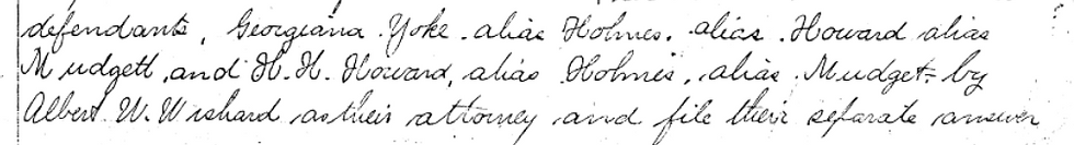
It reads:
defendants, Georgiana Yoke, alias Holmes, alias Howard, alias Mudgett, and H. H. Howard, alias Holmes, alias Mudgett.
One doesn't have to look far to find the man behind the many aliases. Georgiana was the third wife of H. H. Holmes, one of America’s first recorded and most notorious serial killers. Tricked by him, they married in January 1894, Georgiana completely unaware of his true identity. At the same time their land was being partitioned, the Yoke family watched as their niece became entangled in one of the nation’s most shocking court cases and the sensational news stories that covered it.
Holmes was captured, tried, and sentenced to death in 1895. Georgiana eventually testified against her husband, helping to secure his conviction. He was executed in May 1896—just two months before the Yoke plat was officially recorded with the Marion County Recorder.
Georgiana remarried in 1898 and settled back into a quiet life in Indianapolis. Her remarkable story, including her role in the trial of H. H. Holmes, is recounted in the book A Competent Witness: Georgiana Yoke and the Trial of H. H. Holmes.
Development comes to the Yoke farm
After the Holmes affair had run its course, the Yoke family turned their attention to developing their former farm into a residential neighborhood south of Garfield Park. In some cases, they oversaw the development themselves; in others, they sold portions of the land to others who undertook the work.
Over time, five distinct subdivisions were created and eventually merged to form the southside Garfield Park neighborhood as it exists today: Berkeley, platted in 1902; Garfield Heights, developed in 1910; Park Crest, established in 1913; Shelby Gardens, added in 1922; and Taylor & Steers Addition, laid out between 1923 and 1926.

Each of these subdivisions has its own unique history. What follows is only a sampling—enough to uncover long-forgotten, sometimes surprising, and occasionally ugly pieces of the area’s past.
Berkeley
The Berkeley addition, the first portion of the former Yoke farm to be developed, is bounded today by Allen Avenue, East Berwyn Street, Shelby Street, and East Troy Avenue.
In July 1901, Charles Yoke sold lots 15 and 16 of the Yoke Heirs Subdivision to Walter B. Perkins. Perkins, a real estate developer from New England, had placed an advertisement in The Indianapolis News a few months earlier, outlining exactly the type of land he was seeking:

Charles Yoke had exactly what Perkins needed. Lots 15 and 16 of the Yoke Heirs Subdivision, totaling 20 acres, were close to the city's rapidly expanding southside street car system.
After purchasing the land, Perkins platted the Berkeley addition and launched the promotion of it with a massive half-page advertisement dripping with the boosterism, urgency, and hyperbole typical of early twentieth-century real estate promotion:

Packed full of information for the prospective buyer, the advertisement had a brief declaration signaling not everyone was welcome:
PROPER RESTRICTIONS fully protect you as to character of neighbors, class of buildings, etc.
Later advertisements carried similar statements:
...we make restrictions against all nuisances, and refuse to sell to undesirable customers.
These statements were part of a larger real estate operation run by Perkins that spread across the United States. Research indicates that Perkins played a role in introducing racially restrictive covenants into communities across the country in the early twentieth century.
Perkins’ real estate activities have been documented in states including Massachusetts, New York, Pennsylvania, Ohio, Michigan, Kentucky, Indiana, Iowa, Missouri, and Alabama. Specifically, the research shows that Italians and people of color were frequently singled out for exclusion in the deeds Perkins attached to his developments.
The language included in the advertisements for the Berkeley addition strongly suggests that similar restrictions were in place for Perkins' Indianapolis endeavors.
Development progressed slowly in the restrictive Berkeley addition. Of the 144 lots originally platted, only thirteen had houses constructed on them by 1906. A decade later, in 1916, the subdivision contained just 31 houses and a single church. Even by 1941, only 81 lots—just over half—had been built upon, a pace likely shaped by the addition’s location at the far edge of the city limits.

Given its early development, some of the oldest homes in Garfield Park's southside neighborhood are located in the Berkeley addition. Built between 1902 and 1908, a few of the best representations of these include 1039 East Berwyn, 1009 East Berwyn, and 1039 Albany.
One house in particular stands out: a peculiar cement-block dwelling at 1005 East Berwyn, oriented in an unusual way. It is the only house in the entire addition whose front door does not face the street. Early research suggests it may have originally stood in the center of Garfield Park, having been relocated from the area after the eastern part of the park was developed in 1914.
A small frame church stands at 2904 Shelby Street, which serves as a private residence today. Built in 1909–1910, it was originally known as the McClainsville Methodist Episcopal Church. Before Indianapolis expanded southward, McClainsville was a small unincorporated settlement centered around the convergence of Troy Avenue, Shelby Street, and Carson Avenue.

The early church was a simple, front-gabled frame structure with a set of double front doors:

In the early 1920s, the congregation became known as the Shelby Street Methodist Episcopal Church. In 1925, the building was expanded with the addition of a wing and a bell tower. The church closed in 1966 and merged with the Barth Place Methodist Episcopal Church—formerly located at Barth Street and Raymond Avenue, now demolished—to form St. Andrew United Methodist Church at 2560 Villa Avenue.
Garfield Heights
Eight years after Berkeley was platted, Garfield Heights emerged immediately to its north in 1910, covering lots 9 and 10 of the Yoke Heirs Subdivision. Today, the addition is bounded by Yoke Street, Allen Avenue, East Berwyn Street, and Shelby Street.
In 1910, Earle Smith, a Yoke grandchild, sold lots 9 and 10 to George L. Maas, president of the Maas-Neimeyer Lumber Company. Two months later, Maas transferred the land to the newly incorporated Indiana Investment and Securities Company, which officially platted Garfield Heights in January of that year.
Unlike Berkeley, which was developed through the speculative marketing of individual building lots, Garfield Heights was a finance-driven project. Lots were held primarily by banks and investment companies, and development proceeded gradually rather than being pushed immediately through active promotion and sale. As a result, little to no newspaper advertising for Garfield Heights exists. One of incorporators of the Indiana Investment and Securities Company was Albert E. Metzger, George’s brother-in-law and a well-known Indianapolis banker and real estate developer.
Albert served as president of the German-American Trust Company, incorporated in 1906. In 1911, roughly half of Garfield Heights’ lots were transferred from the Indiana Investment and Securities Company to the German-American Trust Company.

The following year, the German-American Trust Company merged with the Marion Trust Company to form the Fletcher Trust Company, where Metzger served as Vice President. The company's beautiful 1915 skyscraper still stands downtown today. A powerhouse in Indianapolis development, Metzger was also responsible for the city's famous Hotel Lincoln, constructed in 1918.
Garfield Heights’ 122 lots eventually passed through multiple financial institutions, often changing hands more than once before reaching individual buyers. As a result, development moved slowly, shaped more by financing than by immediate demand.
Like the Berkeley addition, Garfield Heights also saw the development of a small church congregation with a connection to McClainsville.
In the early 1920s, a group of Lutherans under the auspices of St. Mark's Lutheran Church in Fountain Square began teaching Sunday school out of the McClainsville Community House. The community house, a former Marion County public school, was located on the northwest corner of Troy and Carson Avenues.

By 1923, a new congregation had grown out of the Sunday school effort and was given the name Bethany Evangelical Lutheran Church. Three years later, in 1926, a modest frame building was constructed at the corner of Shelby and Yoke Streets on lots 1 and 2 of Garfield Heights, serving as both chapel and parsonage.
A decade of steady growth soon made a larger space necessary. In 1936, the congregation added a charming Gothic Revival sanctuary faced with Indiana limestone to the front of their original building, giving the church a more permanent and distinguished presence in the neighborhood.

Bethany Evangelical Lutheran remained in Garfield Heights until 1960, when the congregation moved to its current location at 4702 South East Street. Their Gothic Revival church still stands on Shelby Street today.
Park Crest
The Yoke family did not leave the development of their former farm entirely to outside interests. In the spring of 1913, the Yoke Realty Company was incorporated by George Yoke, his nephew Charles R. Yoke, his niece Jesse Yoke Green, and her husband, Hadley Green.
Drawing on land they had inherited, the family selected lots 1, 2, 3, 7, and 11 of the Yoke Heirs Subdivision and platted the Park Crest addition in 1913. Charles R. Yoke had received lots 1 and 7 from his father, Nelson, who died in 1905. Jesse Yoke Green inherited lots 2 and 11 from her mother, Catherine Yoke Manker, who also died in 1905. Lot 3 was among those originally inherited by George from his parents.
Like the Berkeley addition in 1902, Park Crest was developed as a speculative subdivision, with lots—some with houses, others empty—aggressively marketed to buyers. The opening sale for lots took place on May 11, 1913.

A 1914 story in The Indianapolis News highlighting Park Crest, likely dictated by George, Charles, and Jesse Yoke Green, harkened back to the time the land was the home of Allen and Isabel:
And now the last bit of ground that Allan Yoke's ax cleared nearly a century ago has been subdivided. Gas mains underly the land, telephone and electric wires—all improvements of which Allan never dreamed—span the land and graded streets and cement walks divide it neatly into city blocks and squares.
The paper continued, romantically:
Where Allan's adz awoke the echoes of the forest as the first of the Hoosier Yokes hewed out his cabin from the timber growing out his own acres, now sounds the carpenter's hammer, constructing modern cottages and bungalows from dressed lumber that must come to the old farm by rail...
The earliest homes in Park Crest were built on the premium lots directly across Southern Avenue, overlooking Garfield Park, and were owned by members of the Yoke family. These include the neighboring residences of George Yoke at 869 East Southern Avenue and Charles R. Yoke at 861 East Southern Avenue, as well as the home at 945 East Southern Avenue, originally belonging to Jesse Yoke Green and her husband, Hadley Green.
The homes of George and Charles were constructed around the time Park Crest was developed in 1913, and the Green House likely around 1905.
The Yoke homes were often featured in advertisements for the subdivision:


Compared to the Yoke family homes, the simple and unassuming cottage at 1025 East Southern Avenue is a bit of an outlier in the neighborhood.
Built c. 1898, it is likely the second oldest home in the entire Yoke Heirs Subdivision. The parcel it sits on was sold by Nelson Yoke in 1898, well before any portion of the Yoke Heirs subdivision was developed.
The home appears on the 1901 Baist Property Atlas, sitting just north of Bean Creek along Southern Avenue.

On the other side of Bean Creek is another home, along with a stable at its rear. This, in all likelihood, is the original Yoke Farmhouse, the oldest home in the neighborhood, now located at 2762 Manker Street.
The home, dating to around the time that Allen Yoke bought the farm in 1842, was originally a simple four room I-House with a wing extending from its back. The 1931 Indianapolis Star article details George Yoke's memories of his family's home:
He remembers seeing timber cut for the frame work of the house; great walnut trees were squared with an adz and set into the building. Inside trim was made by hand from walnut, grooved and rubbed to satin smoothness.
There are four rooms eighteen feet square, two up and two downstairs. In a wing were the large dining room and kitchen with the fireplaces where cooking was done on an open fire fitted with cranes. The staircase was boxed in with a door three steps off the floor.
Included in the article is a grainy photograph of the home in what was presumably its original setting:

The house is documented in its original location as early as 1895, when the Yoke Heirs Subdivision was platted. In court records, the house was listed as being located on lot 1, in the northeast corner of the Yoke farm:

The record reads:
That said block numbered one (1) contains within its boundaries the following described improvements, to wit: one frame Homestead residence, one smoke house, one wood house, one carriage house, one poultry house, and two barns nearest to said residence.
The 1901 Baist Property Atlas shows the entire Yoke Heirs Subdivision before any development took place on the land, and indicates that the only structures present were located on lot 1. The house at 1025 Southern Avenue can be seen to the north of Bean Creek, and the Yoke farmstead to the south.

The structures appear again in the 1908 Baist Atlas, and by the 1916 Atlas, three years after the Park Crest addition was platted, the house is gone from lot 1. Sometime between 1908 and 1916, the house was moved to its present location on Manker Street.
The house was caught in a 1917 advertisement for Park Crest in The Indianapolis Star, when the Yoke Realty Company took a bird's-eye photograph of four newly constructed houses on Cruft Street (today Willow Drive):

The Yoke farmstead, with its gable that was likely a later alteration, is barely visible in the distance, surrounded by empty lots:
Those with an eye for historic architecture who drive down Manker Street today will quickly notice that the mid-nineteenth-century Yoke farmhouse feels strikingly out of place among the early twentieth-century cottages and bungalows that define the neighborhood. The home's pressed concrete block foundation is another tell of its relocation; the original foundation likely would have been of brick or fieldstone.
Still standing proudly today, it holds the area's history firmly within its walls.
Shelby Gardens
The fourth development to take shape on the former Yoke farm came in 1922 with the platting of Shelby Gardens, a sixty-lot subdivision bounded by Nelson Avenue, Shelby Street, Yoke Street, and Manker Street.
The word “garden” in the subdivision’s name likely reflects how the land was used before its transformation into a residential neighborhood. The ten-acre parcel, originally inherited by Richardson Yoke Jr., passed to his wife, Josephine, upon his death in 1905. In 1908, Josephine sold Lot 8 to Henry Buescher and his wife, Lena. In the 1910 and 1920 censuses, Henry was enumerated as a “gardener,” with his enterprise described as a “truck farm” or “garden farm.”
Truck farming had nothing to do with motor vehicles. The term instead derives from the French word troquer, meaning “to barter” or “to exchange,” and referred to the cultivation of vegetables for sale in local markets.
Truck farms, sometimes also called garden farms, emerged as a distinct and widespread industry in the late nineteenth and early twentieth centuries, as rapidly growing cities created a steady demand for fresh, perishable food. Before widespread refrigeration and long-distance shipping, produce had to be grown close to where it was consumed, giving rise to small, intensive farms clustered along the urban fringe. These farms were often only five to twenty acres in size.
A 1915 sale advertisement in The Indianapolis Star painted truck farms as an idealistic and picturesque endeavor:

Before purchasing his ten-acre tract south of Garfield Park, Henry operated a truck garden along Madison Avenue in an area that was known as “Windmill Alley”—a name derived from the numerous windmills that once dotted the landscape, pumping water to irrigate clusters of truck and garden farms, many of them operated by German immigrants. Henry and Lena themselves were first-generation German Americans.
A 1905 feature in The Indianapolis News captured the character of Windmill Alley:
The panorama of the valley, and the higher lands to the south, carry one's thoughts back to the French lands and the Deutsch lands, where the fields are mere patches of different shades of green crops...
There are fully fifty truck farms in the valley at this time, and probably there are that many more on the highlands to the south. Most of these truck, or garden, farmers raise three crops a year.
The "highlands to the south" referred to a broader landscape of German truck gardens, a history that is today memorialized by a historical marker at Bluff Road and Hanna Avenue.
A year after purchasing the ten-acre lot in the Yoke Heirs Subdivision, Henry, Lena, and their four sons moved from Madison Avenue to Shelby Street, directly across from their new land.
While no direct evidence has been located yet that confirms this parcel was used as a truck garden, multiple facts point strongly in that direction: Henry’s occupation in the 1910 and 1920 censuses, the lot’s location on the city fringe, its size, and the fact that no development took place on it from 1908-1922.

As the Bueschers operated their truck farm along Shelby Street, they watched as house after house rose around them. The financial incentive to subdivide their ten-acre tract likely became impossible to ignore as the neighborhood south of Garfield Park began to fill in.
Henry and Lena platted Shelby Gardens on July 3, 1922, choosing a name that reflected both the street it fronted and the industry the land had once supported. A year later, they sold all of the Shelby Gardens lots to an investment company, returned to Madison Avenue, and continued in the truck farming business.
Taylor & Steers Addition
The Taylor & Steers Addition—today bounded by Stanley Avenue, Allen Avenue, Nelson Avenue, and Yoke Street—was never intended as a residential development.
That, at least, was the vision of Paul P. Parker, founder and president of the Parker Tire & Rubber Company, and his investors. Instead, it was meant to serve as the epicenter of a booming tire industry.
The story of Mr. Parker and his tire company extends far beyond what can be told here (perhaps the subject of a future post), but a few key moments help round out the history of Garfield Park’s southside neighborhood.
Born in Illinois in 1890, Parker worked for several tire companies in Ohio during the 1910s before striking out on his own. The Parker Tire & Rubber Company was incorporated in Delaware in January 1918 with an initial capital stock of $750,000.

Shortly after, the company began placing advertisements in Indianapolis papers announcing that the city had been chosen as the site for their new factory, and encouraged investors to purchase stock.
Lot 6 of the Yoke Heirs Subdivision was purchased by the company in March 1918 for $10,000. By fall of that year, their modest $30,000 factory along Nelson Avenue, small by the standards of established tire manufacturers, was completed:

This 1919 photograph of the newly completed factory, still standing today at 2702 Applegate Street, shows a remarkably clear view of a portion of Garfield Park's southside neighborhood early on in its development. To the south of the factory stands a collection of recently-constructed homes in the Park Crest addition, on Yoke and Cameron Streets:

The first few years of the company appeared promising; the market demand seemed to be there, as was the enthusiasm of stockholders and investors. So much so that the company increased its authorized capital stock to $3,000,000 in early 1920.
This was an ambitious move for a newcomer to the tire and rubber business, signaling that Parker Tire & Rubber was attempting to break into an industry already dominated by firms with capital stock in the tens of millions, including giants like Goodyear Tire & Rubber Company and Firestone Tire & Rubber Company.
Parker Tire was entering an increasingly crowded field, as dozens of new tire companies had been organized in the preceding decade to capitalize on the rapid growth of the automobile industry, creating a high level of competition.
The increase in capital stock was undertaken to support a major expansion of the company’s operations, including a new $500,000 factory, in addition to a general office building that would include a residence for Mr. Parker on the second floor. The additions would occupy the entirety of the Yoke block the company purchased in 1918:

Unfortunately, the company's plans never materialized.
Despite claims that existing demand was already consuming the factory’s output and that additional facilities were imperative, the company struggled to translate its ambitious capitalization into sustained operations. Ultimately, a brief but sharp recession after World War I, over purchasing of raw materials, and a drop in the price of tires spelled doom for the four-year-old company.
By 1922, financial difficulties overwhelmed Parker Tire. After a suit was filed by a creditor, a receiver was appointed by a judge and a sale of the company's assets, including all real estate, was ordered.
The Parker Tire factory building was first sold in 1923 and repurposed for the production of veterinary drugs for poultry farmers. In 1927, it changed hands again and became a shopping bag factory, a use it retained through the 1950s.
The remaining vacant land formerly owned by the company was also sold in 1923 and subsequently developed into the residential Taylor & Steers Addition that exists today. Mr. Parker left Indianapolis soon after, never returning to the tire industry.
In the end
Garfield Park’s southside neighborhood is a perfect example of why I am so passionate about local history and place-based research. Within its roughly 160 acres, countless stories are waiting to be uncovered, and my aim here has been to highlight just a few of them. It’s easy for us to move through our present-day environment completely unaware of the history that shaped it, assuming the way it appears today is the way it has always appeared.
Landscapes often labeled as “ordinary” are prone to being overlooked by historians. They are overshadowed by what is deemed more extraordinary or newsworthy, yet these everyday places often hold rich stories that have shaped the world we live in. By looking closely at Garfield Park’s southside neighborhood, we can see how even the seemingly ordinary contains layers of history, connecting us to what came before and proving that every place has a story worth telling.

